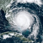
 From Wednesday, August 28th through Wednesday September 4th, our coast was on high alert. Hurricane Dorian roared to within 60 miles of the South Florida coastline, near Martin and Palm Beach Counties.
Early forecasts projected that the storm would crash into Palm Beach with Category 4 strength winds (maximum sustained at 130 to 156 mph). Destruction there would have been close to the catastrophic impact sustained in the Grand Bahamas.
Some forecasts showed a storm track crossing the Florida peninsula to get loose in the Gulf of Mexico. However, once Dorian stalled over the Bahamas, revised forecasts put it on a northern path aimed at Jacksonville. The combined “spaghetti ensembles” using both of the best “models”* closely correlated to a north/northwest track, changing to north/northeast once the upper level steering currents took effect.
Dorian’s stall was unprecedented – historic. Even so, it allowed the storm intensity to wane as it churned up cooler subsurface waters. When the upper level (+18,000 to 20,000’) currents started to coax the storm north, it was downgraded from a Category 5 showcasing a crisp and tight eyewall (over the Bahamas) to a Category 3 with a ragged-edged center and a wobbly track.
Then what happened? Dorian interacted with the Gulf Stream.
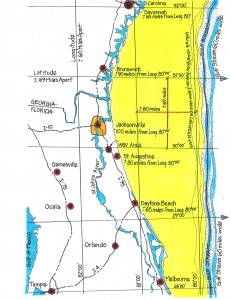
It is important to understand that although the approximately 60 mile wide Gulf Stream contains warm surface and deep waters moving northward at up to 5.6 miles per hour, the Stream itself is not a steering mechanism for a storm.
Dorian’s ragged eye and disturbed center was able to gather over the Gulf Stream and regain its core characteristics as it fed off of the warmer, deep waters. As it continued to gather itself, it began to track along with the Stream, steered by the upper level currents. Note : I learned this from the First Coast News Meteorologist, Tim Deegan.
That dynamic proved to be great news for our area. You can see from the diagram that the western edge of the Gulf Stream is 80 to 100 or more miles east of our coastline. That creates a sort of natural buffer. Additionally, we are further sheltered by being the westernmost community on the eastern seaboard.
Storms that track along the Gulf Stream have their maximum energy fields out to the northeast and east, over the open ocean. Because of this aspect, it is always better to be on the west side of a hurricane, as it moves north.
read more +
 How is the Datil pepper like St. Augustine? We are both fairly small and delectably sweet with lots of spicy flavor, and we share a rich First Coast history!


 An exciting new Caribbean themed festival will launch in St. Augustine this weekend! The 1st annual Jerk & Curry Music Fest will take place on Saturday, September 14 from 12 noon to 10 p.m. at Francis Field in the historic district.
 From Wednesday, August 28th through Wednesday September 4th, our coast was on high alert. Hurricane Dorian roared to within 60 miles of the South Florida coastline, near Martin and Palm Beach Counties.
 St. Augustine’s 4th annual Sing Out Loud Festival is kicking off this weekend at venues throughout the historic district and organizers are expecting the biggest crowds ever! Concerts are planned for each weekend from Friday, September 6 through Sunday, September 29.
 Being the No. 1 school district in the state means more and more families are moving to the area to take advantage of the outstanding schools. Compared to last year’s first day of school, this year’s first day saw a 6% increase in students county-wide, or 2,240 additional kids.
 St. Augustine’s newest residents fit perfectly into our laid back, coastal lifestyle. In fact, they sleep up to 20 hours a day and spend most of their time lounging in trees at their new home in the St. Augustine Alligator Farm Zoological Park.
 Now that school is back in session, IMAX is offering the chance to extend learning beyond the classroom! Documentary Days at the World Golf Hall of Fame IMAX Theater will kick off tomorrow, Friday, August 16 and run through Thursday, September 5.


